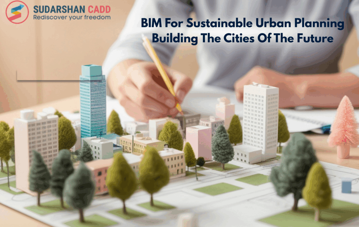
BIM For Sustainable Urban Planning Building The Cities Of The Future
As cities continue to expand rapidly, the demand for sustainable and intelligent infrastructure has never been greater. Urban planners, architects, and engineers are turning to Building Information Modeling (BIM) as a key enabler of smart city development. BIM’s ability to create data-driven, collaborative, and visually intelligent models allows cities to evolve in a way that balances growth with sustainability, efficiency, and livability.
The Role of BIM in Urban Planning
- mostbet
- mostbet az
- pinup casino
- mostbet
- pinup casino
- mostbet
- 4abet
- mostbet az
- 1win
- pinup
- mosbet
- farabet casino
- 1win yüklə
- mostbet casino
- pinko
- 1 win
- 1vin casino
- chicken road uz
- mosbet kz
- 4rabet login
- pinup uz
- 1win tr
- pinco casino
- mosbet kz
- pin up casino
- chicken road game
- mostbet uz casino
- snai
- mosbet
- 1win casino
- pin up casino
- mostbet aviator
- pinko
- pin up
- pinup az
- pinko casino
- pinup
Building Information Modeling goes beyond traditional design—it integrates spatial, environmental, and infrastructure data into a unified digital ecosystem. Urban planners use BIM to analyze land use, transportation, water networks, energy consumption, and environmental impact before construction even begins.
BIM enables:
- 3D visualization of complex city models for better planning and communication.
- Integrated data management, connecting all stakeholders—engineers, planners, and government bodies—through a shared platform.
- Scenario simulations for evaluating infrastructure performance and sustainability outcomes.
This data-centric approach ensures that every decision contributes to creating resilient and sustainable urban environments.
Sustainability Through BIM: Key Benefits
Integrated and Data-Driven Design:
BIM helps stakeholders access a single source of truth. By integrating GIS data, topography, and infrastructure systems, planners can assess how new developments interact with their environment. This leads to better land-use efficiency, optimized energy performance, and reduced ecological footprints.
Environmental Impact Analysis:
BIM models can simulate daylight, energy consumption, air flow, and heat distribution. These analyses support sustainable decision-making — for example, optimizing building orientation to minimize energy use or designing efficient stormwater drainage systems to prevent urban flooding.
Smart Resource Management:
Through BIM, cities can manage resources more intelligently. Material quantities, energy performance, and waste reduction strategies are embedded within models, enabling a circular economy approach where data supports long-term resource optimization.
Disaster Resilience and Risk Management:
Cities are increasingly vulnerable to natural and human-made disasters. BIM supports risk analysis and emergency planning by simulating disaster scenarios — from floods to earthquakes. Accurate 3D data allows authorities to plan evacuation routes, assess damage risks, and strengthen resilience strategies before crises occur.
Collaboration Across Stakeholders:
Urban development involves architects, civil engineers, environmental experts, and government agencies. BIM enables real-time collaboration, reducing data silos and decision delays. Every stakeholder works from an accurate, shared model, improving transparency and accountability.
Lifecycle Management and Digital Twins:
By integrating BIM with IoT and AI, cities can develop digital twins — real-time digital replicas of physical assets. These twins allow continuous monitoring of urban infrastructure (roads, water systems, energy grids), predicting maintenance needs, and optimizing resource allocation for long-term sustainability.
Holistic Visualization of Urban Environments:
Traditional CAD drawings show only parts of a project. BIM creates 3D digital twins of entire neighborhoods or cities, allowing planners to visualize how new developments fit within existing contexts—topography, transportation networks, and environmental conditions.
Infrastructure Coordination and Clash Avoidance:
BIM ensures coordination between multiple infrastructure systems—roads, utilities, transport hubs, and green spaces—by detecting clashes before they occur.
The long term benefits of using BIM
Significant Cost Savings Overtime:
While BIM requires an initial investment, it pays off through the entire project lifecycle by minimizing rework, delays, and design clashes.
Facilities management teams can also use BIM data for preventive maintenance and resource optimization.
➡ Benefit: Lower operational and maintenance costs, and maximum return on investment (ROI).
Enhanced Asset and Facility Management:
Once construction is complete, BIM continues to serve as a digital twin for the facility.
Owners can track building components, schedule maintenance, and plan renovations using accurate, up-to-date information.
➡ Benefit: Increased asset value and extended building lifespan.
Energy Efficiency:
BIM models integrate performance simulations that predict energy use, daylighting, ventilation, and carbon footprint.
This data helps optimize long-term sustainability and achieve environmental certifications like LEED or BREEAM.
➡ Benefit: Reduced environmental impact and lower energy consumption over decades.
Seamless Collaboration and Knowledge Retention:
All project data remains centralized in a BIM model, preserving institutional knowledge even if team members change.
It also ensures smooth collaboration across disciplines and over project phases.
➡ Benefit: Consistent workflows and easier project handovers across years or generations.
Future-Proofing for Urban Growth and Smart Cities:
As urban areas expand, BIM models can integrate with GIS, IoT, and AI systems to support smart city planning and infrastructure upgrades.
➡ Benefit: A scalable foundation for long-term urban resilience, adaptability, and digital transformation.
Time Efficiency in Renovation and Retrofits:
With accurate as-built data available from BIM, future renovations or extensions can be planned quickly and accurately—without repeating surveys or redesigning from scratch.
➡ Benefit: Faster project turnaround and reduced design duplication.
Enhanced Risk Management and Safety:
BIM allows for better risk assessment, clash detection, and safety planning from day one.
In the long term, it helps minimize accidents, claims, and operational hazards.
➡ Benefit: Safer projects and reduced insurance costs.
How BIM Supports Urban Planning Projects Throughout Each Stage
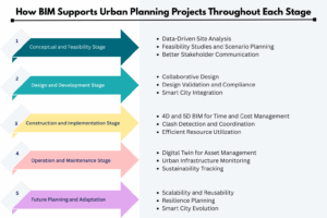
Conceptual and Feasibility Stage:
At the earliest stage of urban development, BIM plays a vital role in creating a clear vision of the project.
- Data-Driven Site Analysis: BIM integrates GIS, topographical, and environmental data, helping planners understand existing site conditions—such as terrain, infrastructure, and utilities.
- Feasibility Studies and Scenario Planning: BIM models allow planners to simulate multiple development scenarios, evaluate land-use efficiency, analyze sunlight and shadow impact, and assess environmental footprints.
- Better Stakeholder Communication: With interactive 3D visualizations, city officials, investors, and the public can better understand design intentions and make informed decisions early on.
Design and Development Stage:
During design development, BIM becomes the digital backbone for coordination between architects, engineers, and urban planners.
- Collaborative Design: Multiple disciplines—structural, MEP, landscape, and infrastructure—work simultaneously in a shared BIM environment, ensuring seamless coordination.
- Design Validation and Compliance: BIM ensures designs comply with zoning laws, environmental regulations, and accessibility standards. Real-time data validation prevents costly redesigns later.
- Smart City Integration: BIM integrates with IoT and GIS systems, helping planners design cities that are not only functional but also digitally connected—essential for future smart city initiatives.
Construction and Implementation Stage:
Once plans move from paper to ground, BIM continues to play a crucial role in maintaining project accuracy and efficiency.
- 4D and 5D BIM for Time and Cost Management: Construction sequencing (4D) and cost estimation (5D) help project managers visualize progress and optimize budgets.
- Clash Detection and Coordination: BIM’s intelligent clash detection minimizes conflicts among different systems (e.g., roads, utilities, and building foundations), reducing on-site delays.
- Efficient Resource Utilization: By simulating workflows and logistics, BIM ensures efficient material use, reducing waste and supporting sustainable construction practices.
Operation and Maintenance Stage:
Even after construction, BIM models continue to deliver value throughout the lifecycle of urban infrastructure.
- Digital Twin for Asset Management: As-built BIM models act as digital twins, providing real-time data for facility management, maintenance scheduling, and performance monitoring.
- Urban Infrastructure Monitoring: Integration with IoT devices allows city managers to monitor energy usage, traffic flow, and infrastructure health, enabling data-driven decision-making.
- Sustainability Tracking: BIM supports carbon tracking, water efficiency, and waste reduction initiatives—crucial for maintaining eco-friendly cities
Future Planning and Adaptation:
Urban environments evolve continuously. BIM data becomes a valuable foundation for future planning and redevelopment projects.
- Scalability and Reusability: Existing BIM data can be reused for future extensions or upgrades, saving time and ensuring consistency.
- Resilience Planning: Planners can simulate the impact of natural disasters or population growth and plan infrastructure accordingly.
- Smart City Evolution: BIM serves as the core digital framework that integrates with AI, GIS, and IoT technologies, turning urban visions into sustainable, intelligent ecosystems.
From Planning to Execution: BIM Across the Urban Lifecycle
BIM adds value at every stage of an urban development project (including future upgrades). It’s a complete system that helps cities grow in an organized and sustainable manner with master planning. BIM allows urban planners to visualize how buildings and roads would function in different scenarios. The 3D models, rich in detail, help assess practicality or financial viability.
During the construction phase, BIM ensures that all new developments are in harmony with the existing infrastructure. For example, let’s consider the scenario where a city wants to erect a new high-rise apartment complex. BIM can show how the complex impacts water pipes, electrical lines, public roads, and pedestrian zones.
BIM: Addressing Key Urban Challenges
Urbanization brings multiple challenges to the fore. BIM can help tackle and mitigate the issues through simulation, predictive planning, and stakeholder coordination. Let’s discuss how BIM accomplishes this.
Tackling Urban Sprawl and Land-Use Conflicts:
Urban sprawl — the uncontrolled expansion of urban areas — often leads to inefficient land utilization, loss of green spaces, and growing tension between residential, commercial, and industrial zones. BIM provides city planners with a data-driven visualization platform that enables informed land-use decisions.
By creating 3D models of entire city blocks, planners can simulate different development scenarios, analyze spatial relationships, and assess the impact on existing infrastructure. BIM also facilitates inter-agency collaboration, ensuring that stakeholders—from environmental authorities to transportation departments—work on a unified digital model.
Enhancing Climate Adaptation and Urban Resilience:
Climate change poses one of the most critical challenges to modern cities, demanding infrastructure that can withstand extreme weather and environmental shifts. BIM, when integrated with Geographic Information Systems (GIS) and environmental data, supports the development of resilient urban models.
Planners can simulate flood risks, heat island effects, and energy consumption, making it easier to design adaptive infrastructure. BIM also supports sustainability certifications by allowing teams to track material performance, energy usage, and lifecycle costs over time.
Overcoming Inefficient Infrastructure Systems:
Aging and inefficient infrastructure often hinders urban growth and public safety. Traditional maintenance approaches rely on fragmented data and reactive management. With BIM, municipalities can create digital twins—virtual replicas of roads, utilities, bridges, and public buildings—to monitor performance in real time.
Through integrated asset management, BIM provides insights into maintenance schedules, energy usage, and resource optimization. This shift from reactive to predictive maintenance saves costs, reduces downtime, and extends asset life.
Conclusion
BIM is no longer limited to the construction of individual buildings—it has evolved into a transformative tool for sustainable urban planning and smart city development. By enabling data-driven decisions, promoting collaboration, and integrating emerging technologies, BIM helps cities become more resilient, efficient, and people-centric.