Creating a Complete Digital Twin of a 600,000 sq. meter Educational Campus Using LiDAR, Scan-to-BIM, GPR, and GIS Technologies
Transforming Campus Infrastructure Through Reality Capture and Digital Twin Technology
As educational institutions continue to expand and modernize their infrastructure, having accurate and up-to-date information about existing buildings, utilities, and assets has become essential. Traditional drawings and legacy documentation often fail to reflect the current site conditions, making renovation, maintenance, and future expansion projects challenging and costly.
Our team recently completed a comprehensive Digital Twin creation project for a large educational campus spanning over 600,000 square meters, leveraging advanced reality capture technologies including Drone LiDAR Surveying, Terrestrial Laser Scanning, Ground Penetrating Radar (GPR), DGPS Surveying, and BIM Modeling.
The project delivered a highly accurate digital representation of the entire campus, including above-ground and below-ground infrastructure, enabling data-driven decision-making for future development.
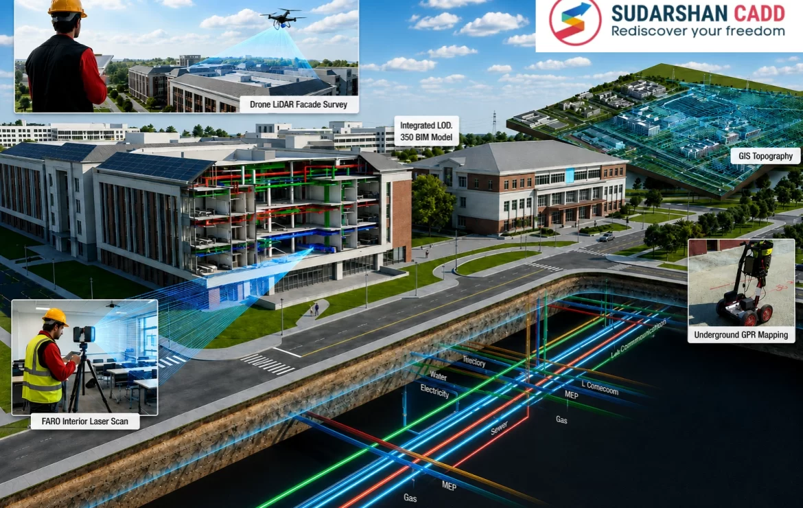
Phase 1: Drone-Based LiDAR Survey and Campus Mapping
The first stage involved conducting an extensive drone survey across the entire campus.
Using high-precision LiDAR-equipped UAVs, we captured millions of geospatial data points covering:
- Existing site topography
- Road networks
- Landscape features
- Building footprints
- Building exteriors
- Architectural facades
- Aerial utility networks
- Site infrastructure assets
The collected point cloud data was processed to create a detailed LOD 200 BIM model representing:
- Site terrain and contours
- External building geometry
- Building envelopes
- Facades and architectural features
- Above-ground utility corridors
This provided the institution with an accurate geospatial foundation model for campus-wide planning and asset management.
Phase 2: Interior Building Reality Capture Using FARO Focus Laser Scanners
Once the exterior environment was digitally captured, the project moved indoors.
Using FARO Focus terrestrial laser scanners, our team systematically scanned the interiors of academic buildings, administrative facilities, laboratories, libraries, auditoriums, sports complexes, and support facilities.
The scanning process captured precise as-built conditions of:
- Architectural elements
- Structural components
- Mechanical systems
- Electrical systems
- Plumbing systems
- Reflected ceiling plans (RCP)
- Interior finishes
- Fixed furniture
- Equipment layouts
- Building services infrastructure
Billions of measurement points were collected and processed into highly accurate point cloud datasets and accurate LOD 350 BIM model.
Based on this information, BIM models were developed representing the actual existing conditions of every building, eliminating uncertainties typically associated with aging documentation and multiple renovation cycles.
Phase 3: Underground Utility Mapping Using GPR and DGPS
One of the most valuable aspects of a true Digital Twin is the inclusion of hidden infrastructure.
To achieve this, we conducted comprehensive underground utility investigations using:
- Ground Penetrating Radar (GPR)
- DGPS Surveying
- Utility Detection Equipment
The survey successfully identified and mapped:
- Water supply networks
- Electrical utility corridors
- Gas pipelines
- Communication conduits
- Drainage systems
- Service crossings and connections
Each utility was accurately geo-referenced and integrated into the BIM environment.
The result was a comprehensive 3D underground utility model that provided complete visibility into infrastructure that had previously been difficult to locate and manage.
Integrating Everything into a Single Digital Twin
The final Digital Twin combined:
Above-Ground Assets
- Site topography
- Buildings
- Facades
- Roads
- Landscaping
- External utilities
Interior Assets
- Architectural spaces
- MEP systems
- Ceilings
- Furniture
- Equipment
Below-Ground Assets
- Water networks
- Electrical networks
- Gas infrastructure
- Utility corridors
- Underground service connections
The institution now possesses a centralized digital representation of its entire campus ecosystem.
Benefits Delivered to the Educational Institution
1. Accurate Existing Conditions for Renovation Projects
Architects and engineers can now design renovations based on verified field conditions rather than outdated drawings, reducing design risks and construction conflicts.
2. Better Planning for Future Expansion
With a complete understanding of existing infrastructure and utility constraints, campus expansion projects can be planned with greater confidence and efficiency.
3. Precise Cost Estimation
Because the Digital Twin reflects actual site conditions, project teams can develop significantly more accurate quantity take-offs, budgets, and construction estimates.
This reduces unforeseen costs and minimizes change orders during execution.
4. Improved Facility Management
Maintenance teams can quickly locate assets, utilities, and equipment, improving operational efficiency and reducing downtime.
5. Reduced Construction Risk
Visibility into underground utilities helps prevent accidental utility strikes and costly disruptions during excavation and construction activities.
6. Long-Term Digital Asset Management
The Digital Twin serves as a living digital record of the campus, supporting future renovations, maintenance, sustainability initiatives, and smart campus programs.
The Future of Educational Infrastructure Management
Large educational campuses are becoming increasingly complex environments that require accurate, data-driven infrastructure management. Digital Twin technology, powered by LiDAR, laser scanning, BIM, GPR, and geospatial intelligence, is enabling institutions to transition from reactive facility management to proactive strategic planning.
By creating a comprehensive digital replica of a 600,000 sq. meter campus, this project demonstrates how reality capture technologies can unlock significant value throughout the entire lifecycle of educational infrastructure.
As campuses continue to evolve, Digital Twins will become the foundation for smarter planning, optimized operations, and sustainable growth.
For more details: https://sudarshancadd.com/scan-to-bim/
Company Details
Company Name: Sudarshan CADD Technologies Pvt Ltd
Website: https://sudarshancadd.com/
Contact Number: +91 9313380923
Email: sales@sudarshancadd.com