Enhances infrastructure planning and management efficiency.
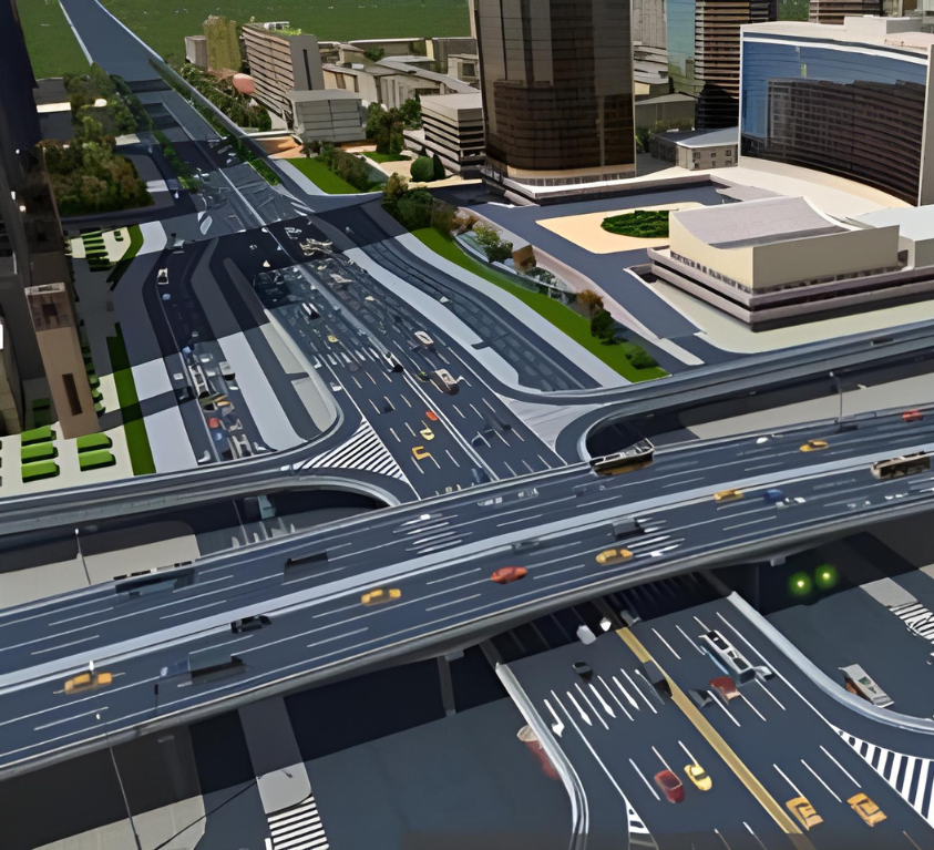
3D Digital Twin Mapping using GIS combines geospatial data with advanced 3D modeling to create a highly accurate, real-time virtual replica of physical assets, infrastructure, or entire environments. This technology allows organizations to visualize assets in three dimensions, simulate real-world conditions, and analyze spatial relationships with greater clarity. By integrating GIS, these 3D models are georeferenced—meaning every element is mapped to its exact location on Earth. This empowers planners, engineers, and decision-makers to monitor performance, predict maintenance needs, and optimize operations in industries such as urban planning, utilities, transportation, and smart cities development.
Bringing the Real World into the Virtual Space with GIS
Geospatial Accuracy
To represent complex systems effectively, GIS technology enables detailed maps and spatial analysis, ensuring a precise virtual model.
Time-Integrated
Unlike static 3D models, GIS-based digital twins reflect changes over time, showing past, present, and future conditions in a continuous, evolving simulation.
Adaptable and Scalable
Whether for small-scale assets or large systems, geospatial digital twins can grow and adapt to meet evolving operational needs and challenges.
Our Core Digital Twin Services
A Digital Twin is a virtual replica of a physical object, process, or system that is used to simulate, analyze, and optimize performance in real-time. At Sudarshan CADD Tech Pvt. Ltd., we offer comprehensive Digital Twin services that bridge the gap between the physical and digital worlds, enabling smarter decision-making and more efficient operations across industries.
3D Modeling and Visualization
Creation of high-fidelity 3D models using CAD/BIM platforms
Accurate geometric representation of assets and infrastructure
Real-time visualization of physical environments
Real-Time Monitoring
Dashboard creation for live asset tracking
Condition monitoring for predictive insights
Remote operations visibility for maintenance and production teams
Data Integration
Integration of IoT sensor data, operational parameters, and historical records
Real-time data synchronization between the physical asset and its digital counterpart
API integration with SCADA, PLC, ERP, and CMMS systems
Lifecycle Management
Asset lifecycle tracking from design to decommissioning
Change management and version control for digital assets
Documentation and compliance history preservation
Simulation and Analysis
Performance simulation under different operating conditions
Predictive maintenance modeling
Risk and failure analysis using virtual environments
Augmented Reality (AR) & Virtual Reality (VR) Integration
Immersive visualization for maintenance, training, and inspection
Hands-free support using AR-enabled devices
VR environments for training and remote design reviews
Applications of 3D Digital Twin Mapping Using GIS:

Urban Development
GIS-based 3D models of cities help urban planners design smarter, more sustainable cities by visualizing traffic, infrastructure, energy use, and more.

Utilities and Infrastructure
GIS-powered 3D models can help manage power grids, water systems, and communication networks, providing a more accurate representation of assets in the field.

Construction & Architecture
Architects and construction professionals use 3D digital twins to visualize building structures, assess design flaws, and collaborate with contractors in a virtual space.
Key Benefits of 3D Digital Twin Mapping Using GIS:
Digital twins drive innovation across industries

Commercial

Water

Transportation

Electric and Gas

Natural Resources

Telecommunications
Optimizes operations through virtual environment analysis.
3D Digital Twin Mapping with GIS offers a powerful combination of spatial accuracy and advanced modeling. It allows organizations to not only visualize the physical world but also predict its future behavior. This enables better planning, real-time analysis, and more efficient management of both assets and infrastructure.

FAQ
Who benefits from using 3D GIS Digital Twins?
Government agencies, city planners, utility providers, facility managers, real estate developers, and AEC (Architecture, Engineering & Construction) professionals all benefit from using 3D digital twins for planning, analysis, and monitoring.
How does GIS enhance a Digital Twin?
GIS adds spatial intelligence to the digital twin by integrating geospatial data such as topography, land use, infrastructure layers, and environmental data. This allows for location-specific insights and improves the twin’s accuracy and usability.
Can real-time data be integrated into the 3D Digital Twin?
Yes. With IoT and sensor integration, real-time data such as traffic flow, temperature, energy usage, and equipment status can be fed into the digital twin, transforming it from a static model to a dynamic, operational tool.
How accurate is a 3D Digital Twin model?
Accuracy depends on the input data sources. Using high-quality LiDAR, RTK GPS data, and updated GIS datasets ensures centimeter-level accuracy, which is crucial for critical infrastructure planning and engineering.
Can existing 2D GIS data be converted into a 3D Digital Twin?
Yes. Existing 2D data (building footprints, elevation maps, utility layers) can be extruded or combined with elevation models and 3D assets to build a comprehensive 3D Digital Twin.