
GIS Basemap Preparation
Optimizes network planning and infrastructure deployment.
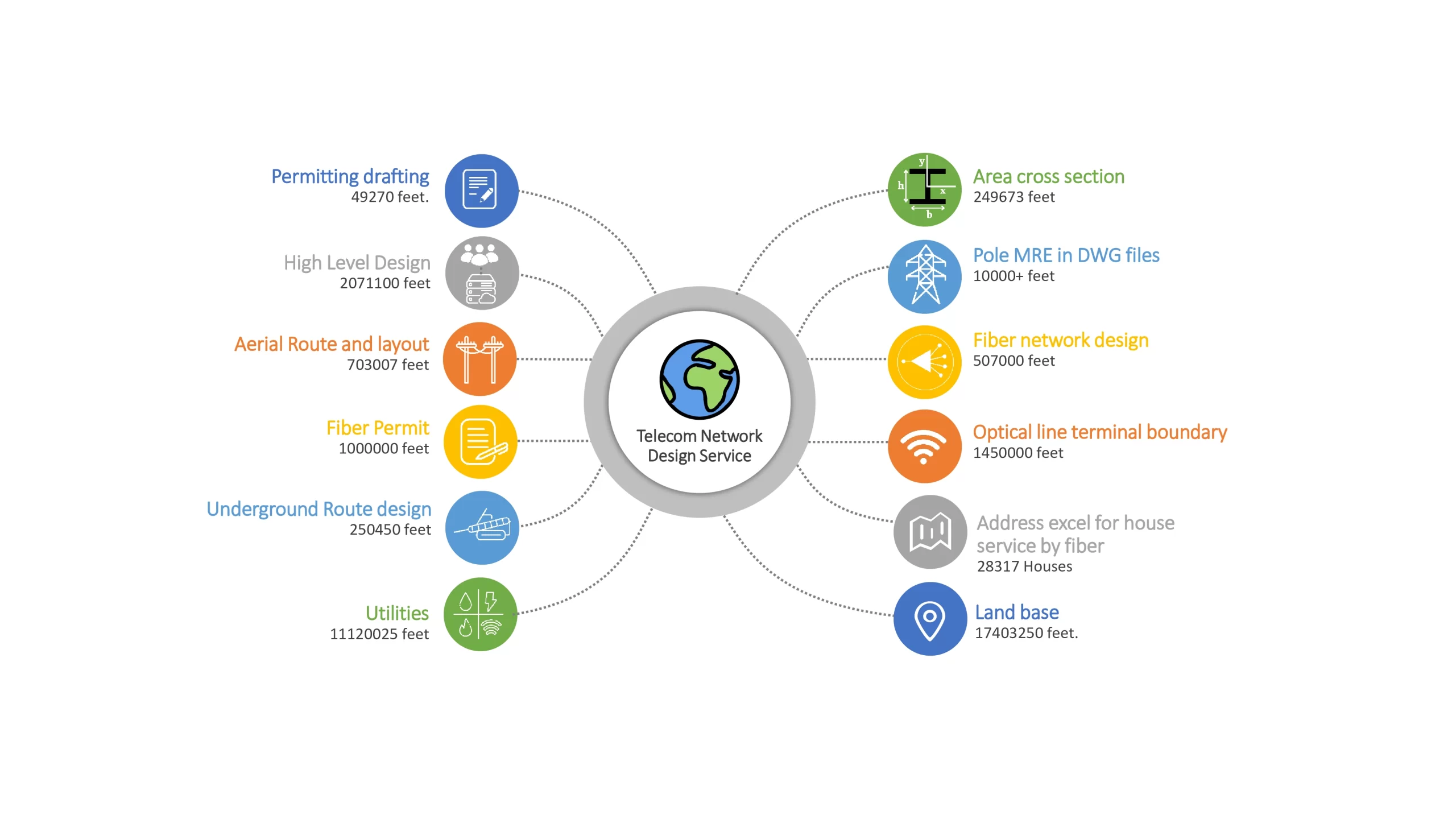
Sudarshan CADD has successfully supported several customers across the GIS Basemap design and drafting services known as GIS Basamap Preparation with a purpose to support global Engineering, Procurement, and Construction (EPC) service providers in planning, designing, managing, and upgrading telecommunications networks. The following are our primary services for the international telecom sector:
Our GIS Basemap Network Preparation & Design Service
What We Do In FTTH Design & Mapping
FTTH Design Services
Accelerating Last-Mile Fiber Deployment with Precision Engineering
Deliver seamless, scalable, and standards-compliant Fiber to the Home (FTTH) networks with our end-to-end FTTH Design Services. We help telecom operators, ISPs, EPC contractors, and infrastructure developers design high-performance fiber networks that ensure faster deployment, lower costs, and long-term network reliability.
Our expert-driven designs combine GIS intelligence, CAD precision, and telecom engineering best practices to support residential, commercial, and mixed-use fiber rollouts across urban and rural environments.
Our Design Capabilities
-
Network architecture planning (GPON / FTTx)
-
Feeder, distribution & drop fiber design
-
Splitter placement & fiber allocation
-
Pole-mounted & underground design layouts
-
BOQ, splicing schedules & loss budget calculations
-
Construction-ready CAD & GIS drawings

Fiber and Broadband
FTTx design and drafting services
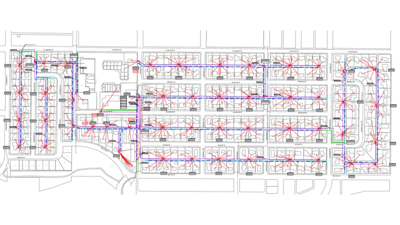
We provide end-to-end FTTx (FTTH / FTTB / FTTP) network design and drafting services to support telecom operators, ISPs, and EPC contractors in planning, building, and maintaining robust fiber optic networks. Our team specializes in GIS-basemap preparation, detailed construction-ready designs, fiber routing, and accurate as-built documentation to ensure efficient deployment, minimal rework, and faster rollouts. From initial feasibility and route planning to final as-built updates, we deliver precise, scalable, and cost-effective fiber network solutions.
Preliminary Network Design & Planning
Low Level Design (LLD)
GIS-Based Network Mapping & Data Management
High Level Design (HLD)
FTTx / Fiber Cable Routing
BOQ & BOM Preparation

OPS Design Services
Scalable, Faster & Future-Proof Fiber Infrastructure
In a world driven by high-speed connectivity, Outside Plant Fiber Network design is the backbone of reliable communication. We deliver precision-engineered, deployment-ready fiber designs that minimize construction risk, accelerate approvals, and maximize long-term network performance.
Our Design Capabilities
-
Route surveys & feasibility analysis
-
Aerial, underground & hybrid fiber design
-
Duct, trench & pole-line layouts
-
Fiber cable routing & capacity planning
-
Splice diagrams, fiber schematics & as-built drawings
-
Permit & ROW-aligned design documentation
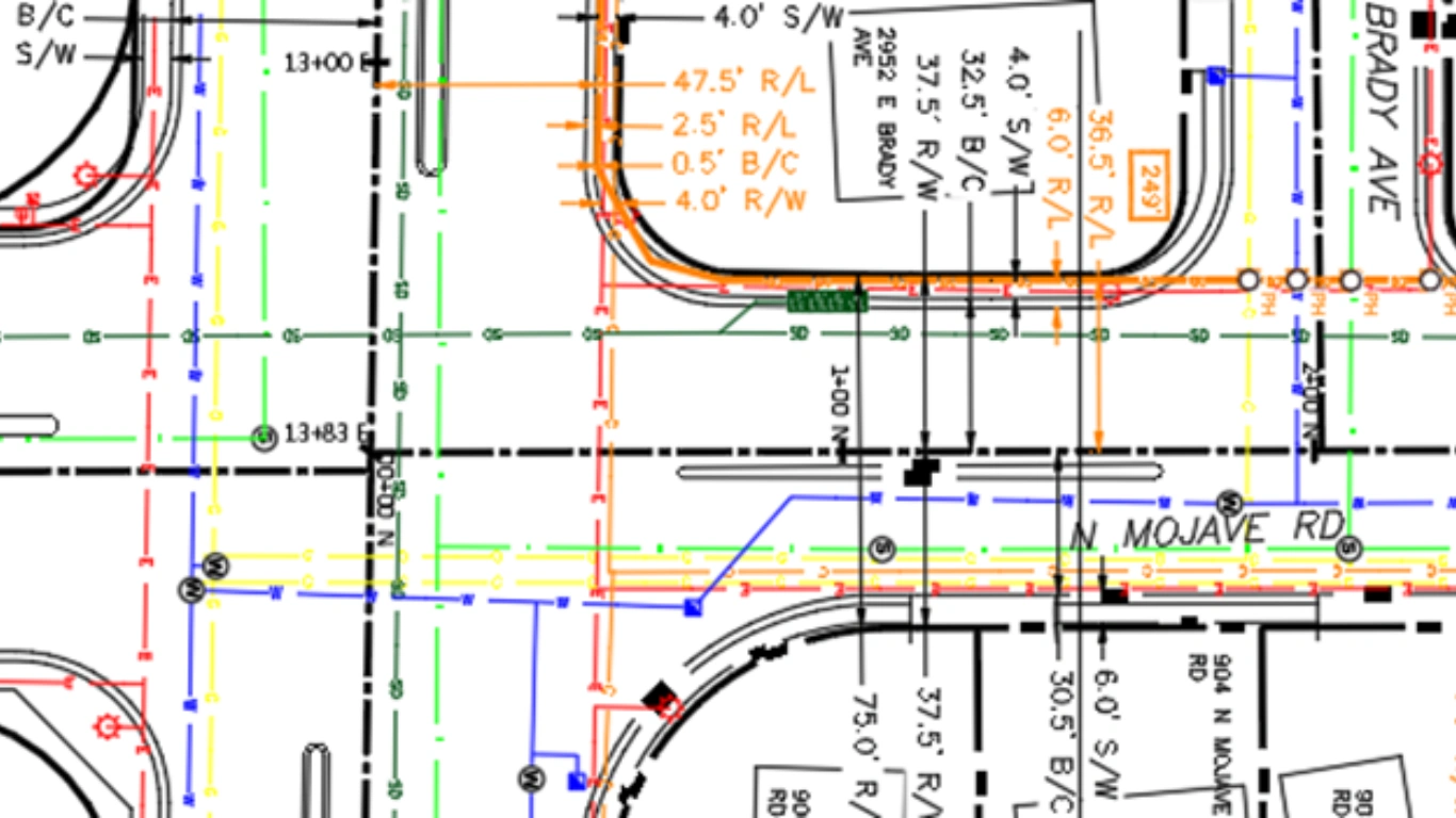
Permitting
Sudarshan CADD helps customers obtain permits from authorities.
(City, County, DOT, Pole owner, Railways etc.) for the initial construction, installation, and operation of all telecommunication networks, in accordance with requirements, procedures, appeal process, and revocation process. With the assistance of base map data from our clients, our team prepares ROW applications, Way Leave agreements, Pole permits, and DOT applications. Sudarshan CADD offers the following Permitting services:
Identification of Complex & Non- Complex, Blanket Permits
ROW & Land base feature Integration
Location Map / Layout
Preparation of Permit Drawings
Documentation as per the permitting authority standards
Construction Package
We develop comprehensive, construction-ready packages for telecom and FTTx design deployment, enabling field teams and contractors to execute work efficiently, accurately, and safely. Our construction packages combine detailed drawings, material take-offs, splice information, and route data into a single, well-structured set of documents that eliminate ambiguity, reduce site errors, and accelerate build timelines.

Construction Drawings (Plan & Profile Sheets)
Single Line Diagrams (SLD)
Fiber Route Maps & Alignment Sheets
Splice Diagrams & Splice Sheets
Bill of Quantities (BOQ) & Bill of Materials (BOM)
Aerial & Underground Network Identification
Cross-Section & Trench Detail Drawings
Traffic Control Plans (TCP) / Work Zone Layouts
Permit & Right-of-Way Drawings
GIS Land Base
We develop accurate and high-quality GIS land-base datasets that serve as the foundational layer for telecom, utility, and infrastructure network planning. Our GIS land-base creation services focus on capturing, digitizing, and structuring real-world features to build a reliable base map for further design, engineering, and asset layers. This land-base acts as the backbone for FTTx planning, OSP design, smart city projects, and utility mapping.
Building Footprint Digitization
Road & Street Network Digitization
Parcel / Cadastre Mapping
Points of Interest (POI) Capture
Utility Corridor & ROW Mapping
Unique ID Assignment & Topology Checks
QA/QC & Data Standardization
How Does GIS Basemap Work?
Our team oversees the entire process from start to finish. During the planning stage, we evaluate multiple considerations. Using Geographic Information Systems (GIS) guarantees precise outcomes. Conventional obstacles have no impact.

High Level Design
Basemapping
Utility Drafting
Low Level Design
Aerial and UG Route design and Backbone path Design
Packaging work
Pre-permit work
Cross-Section
Critical Crossing
Prelim and Final fiber work
Ocalc
MRE
Traffic Control Plan
Why Choose Us
Streamlines permit and regulatory compliance processes.
As a GIS Basemap Solutions Company, our specialists use their hands-on experience in geospatial data services and advanced GIS software solutions to create digital twins, cloud platforms, and customer-centric solutions.
Fast turnaround of your GIS projects
First Time Right permitting drawings
Accurate GIS documentation
Reduce cost of spatial data analysis

FAQ
What is GIS basemap preparation?
GIS basemap preparation is the process of creating a geospatially accurate foundational map that supports planning, design, and asset management. A GIS basemap includes layers such as roads, parcels, utilities, buildings, contours, and administrative boundaries, forming the backbone for advanced GIS analysis and network design.
Why is a GIS basemap important for engineering and infrastructure projects?
A high-quality GIS basemap ensures spatial accuracy, data consistency, and regulatory compliance. It reduces design conflicts, prevents costly rework, improves collaboration between stakeholders, and enables faster decision-making across telecom, utilities, transportation, and construction projects.
Can GIS be used for mapping?
Yes, GIS (Geographic Information Systems) is commonly used for mapping in various industries, including telecom. It allows for spatial analysis, data visualization, and mapping of infrastructure, resources, and services.
How does GIS basemap preparation support FTTH and OSP network design?
For FTTH and OSP projects, GIS basemaps provide route feasibility, utility clearance, pole and duct mapping, ROW analysis, and permit-ready documentation. This significantly reduces deployment risks and accelerates network rollout.
What is FTTH design and why is it important?
FTTH (Fiber to the Home) design is the process of planning, engineering, and documenting a fiber-optic network that delivers high-speed internet directly to residential and commercial premises. A well-engineered FTTH design ensures optimal bandwidth, long-term scalability, cost efficiency, and faster network deployment with minimal rework.
Which is better, FTTH or broadband?
FTTH (Fiber to the Home) is generally better than traditional broadband because it uses fiber-optic cables instead of copper or coaxial lines. FTTH delivers much higher internet speeds, lower latency, better reliability, and future-ready scalability, making it ideal for modern applications like 4K/8K streaming, cloud computing, online gaming, and smart homes. For long-term performance and high-bandwidth needs, FTTH is the superior choice.
What are OSP fiber network design?
OSP (Outside Plant) fiber network design is the engineering process of planning and designing external fiber-optic infrastructure such as ducts, poles, handholes, splice enclosures, and fiber routes that connect central offices to end users. It ensures high-performance, scalable, and regulation-compliant fiber networks.
What is the difference between OSP and ISP fiber design?
OSP fiber design focuses on external infrastructure such as roads, poles, ducts, and handholes, while ISP (Inside Plant) design covers in-building fiber routing, equipment rooms, racks, and termination panels. Both are essential for a complete fiber deployment.