
Mapping and Navigation
GIS For Construction: We Have Expertise In Navigational Content Generation To Help Companies Develop Cutting-Edge Solutions.
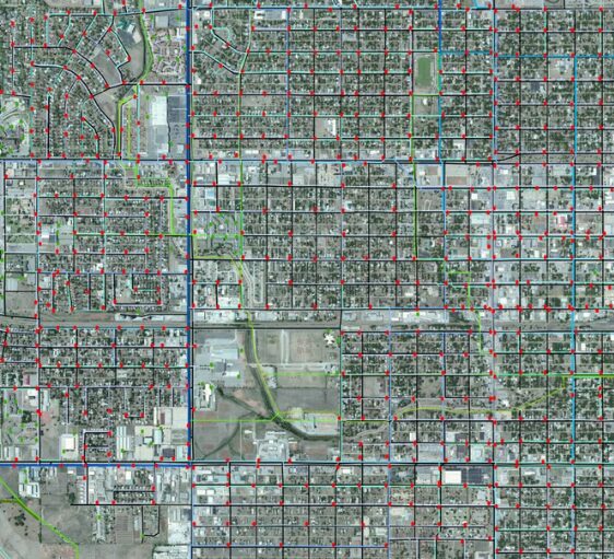
Navigation solutions that improve driver safety and experience. SCADD is an end-to-end service provider in the mapping and navigation geo-content arena, with a balanced mix of on-site and off-site staff. We collect navigation map data from a variety of sources, including high-resolution aerial imaging, satellite imagery, vehicular and manual survey inputs, and on-the-ground photography. Our GIS For Construction including mapping and navigation services require attention to finer features such as grid alignment, precise dimension capture, positional accuracy, and content completeness. SCADD has helped worldwide organizations construct faultless navigation experiences for their end customers by providing the following services:
How Do We Work For Navigation As a GIS For Construction?
01
objective
02
Collect data
03
Digitalize data
04
Create Map
05
Maintain
Our GIS For Construction Services
Mapping Services
2D Building Footprints Digitization
SCADD creates customized 2D building footprints with reference to high resolution
Satellite photos are used to generate building footprints, base and hollow parts of buildings, and building features that crisscross or cross the city, among other things. The following are the main features:
Attribution
Building footprint derived from high-resolution satellite images and aerial images
Experience of capturing large volumes of data directly or via remote access


Survey Services
Road and Street Network Data Creation
SCADD has an expert team who creates accurate road and street network
Data is collected utilizing vehicle-mounted single or multi-camera systems to identify street/road linkages and their associated properties. These services are tailored to each client's individual needs. Our Road and Street Network Data Creation Service includes:
Classification of roads and streets
Digitization of road and street data from various source inputs
Addition of other specified attributes based on customer requirements
3D Data Creation in Construction
Our Portfolio & Project Milestone

500
+
Repeat Business

100
+
Global Client

350
+
Completed Projects

12
+
States Served with Gov. bodies
Why Choose Us
Why Choose Us For GIS In Construction?
As a GIS Solutions Company, our specialists use their hands-on experience in geospatial data services and advanced GIS software solutions to create digital twins, cloud platforms, and customer-centric solutions.
Fast turnaround of your GIS projects
First Time Right permitting drawings
Accurate GIS documentation
Reduce cost of spatial data analysis
FAQ
What is GIS in construction?
GIS in construction refers to Geographic Information System technology used for mapping, analyzing, and managing spatial data related to construction projects, aiding in planning, design, and resource management.
What types of data are used in geospatial services?
Geospatial services utilize a wide range of data sources, including satellite imagery, aerial photography, LiDAR (Light Detection and Ranging) data, GPS (Global Positioning System) data, GIS (Geographic Information System) data layers, survey data, and demographic data. These data sources provide valuable insights into the physical and human characteristics of the Earth's surface.
What is geospatial data for construction?
Geospatial data for construction refers to location-based information, including maps, satellite imagery, and survey data, used in construction projects for site analysis, planning, and decision-making.
Is GIS useful for civil engineering?
Yes, GIS is highly beneficial for civil engineering as it enables better spatial analysis, site selection, infrastructure planning, and environmental impact assessment, enhancing project efficiency and accuracy.